I’m writing this blog entry from the flight home. We’ve had an incredible time in Hawaii and it’s really bittersweet to be heading back to the UK. Kaua’i had it’s ups and downs but overall was a great experience.
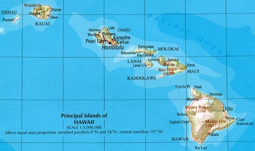
After the Big Island we flew to Kaua’i– the second-to-last island. It’s known as the ‘garden island’ as it’s so green (largely due to heavy rainfall) and the amazing flowers and plants there.
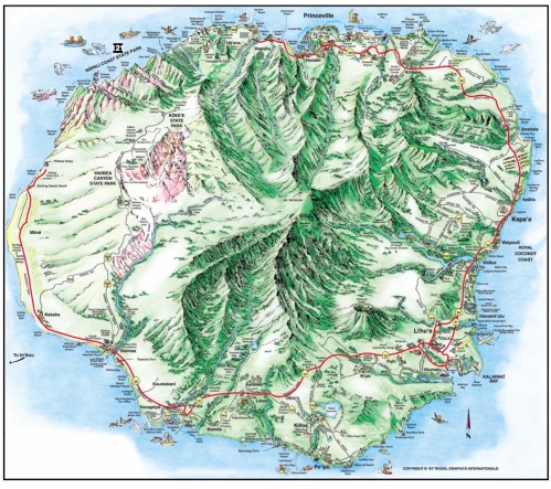
We flew in to Lihue and rented a car there, stopping at Wailua falls and Kilauea beach on our way north to the town of Kapa’a. We spent a night there while preparing to start the Kalalau trail the following day. This involved buying food (not an easy task in Walmart- don’t be fooled) and camping gas (an even harder task). We packed up 4 day worth of granola bars, mac ‘n’ cheese, and instant potatoes- not the delicious local salumi and fresh bread and fruit that we usually pack in the Alps. Finding camping gas was a serious issue- in the end we bought the last can on the entire island (it’s not a very big island, but still). If anyone is thinking of going + cooking on a european-style stove make sure you ring around the camping stores on the island in advance- otherwise prepare to eat a lot of sandwiches… We had brought the rest of our gear from home (amazing tent included), and decided to eschew sleeping bags in favour of one big blanket- it’s Hawaii right?! who needs sleeping bags?
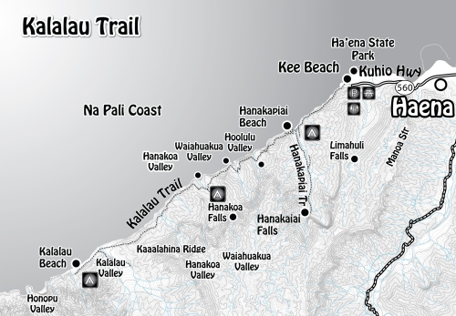
Map of the Kalalau trail- credit: http://www.youhikeapps.com
So the Kalalau trail is 11 miles along the Na Pali coast, and the places that you hike into are only accessible on foot. It’s a linear walk so you have to retrace your steps to get back out. There is an area where you are permitted to camp at mile marker 6 (Hanakoa) and another at mile marker 11, where the trail ends. Most people hike to Hanakapi’ai beach at mile 2 and then back out in 1 day. Those who choose to do a multi-day trek need to book camping permits well in advance, and generally spend 1 night at mile 6, one at 11, one at 6 and then finish the next day. Each camping permit costs $20. But be warned- although the distances sound short on the flat there is a lot of ascent and descent into each valley. It also can get very hot, and large parts of the trail are exposed. All of this we were prepared for, and yet…
Day 1 (trailhead to Hanakoa) started off nicely- we had a hearty breakfast of blueberry/macadamia nut pancakes before parking at the YMCA at Camp Naue and beginning the trek. It’s a 2 mile walk along a road from the YMCA to reach the start of the trail. There was no sign-in or entry to be paid. We hiked to the Hanakapi’ai beach, which has claimed many lives in the past- there’s a sign on the trail which says 83+. The waves hitting the shore here are huge, and slam up against huge rock faces either side of a narrow beach. There’s a trail you can follow to see the waterfall up the valley but we decided to continue to Hanakoa. It was getting very hot but luckily there were plenty of rivers to collect water from (don’t worry- we always filter the water now, we have learned our lessons!). The trail itself is really beautiful but very bumpy and overgrown in parts. One annoyance is that it’s apparently a ‘thing’ to take a tour of this coast by helicopter- which means that the whirr of helicopter blades overhead interrupts your thoughts every 20 minutes or so. When we arrived we were wrecked, so we pitched the tent and took a short nap before deciding to do the Hanakoa falls hike before sunset. This was only approx 30 mins each way, but was uphill and the path was very overgrown which made things a little trickier. Anyway it was well worth the effort and when we got to the top we had the place to ourselves. After a dinner of ‘bangers and mash’, camping style, we hit the hay. We woke up a few hours later to the sound of torrential rain. This happened on-and-off all night, and early the next morning we had the horrible realisation that the ground was wet underneath us.
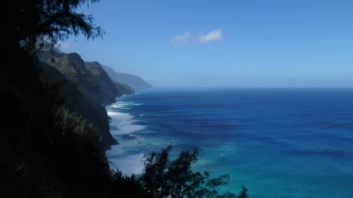
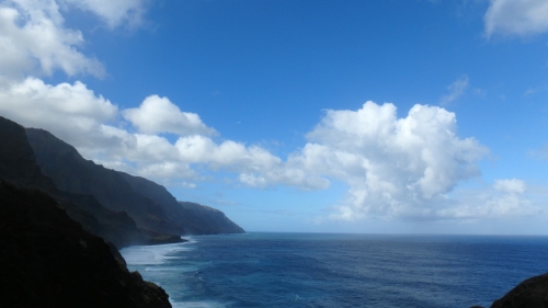
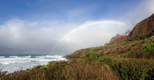
View along the Na Pali coast
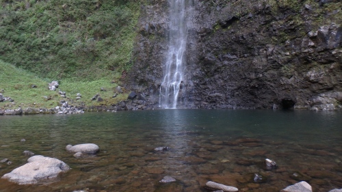
Hanakapi’ai falls
Day 2: We woke up before sunrise, and lay awake listening to the rain falling/pouring on our tent. Eventually Luca got up and came back with a report- our tent was in a puddle. Finally the rain let off and we hung as much as we could, hoping it would have time to dry. However the camping area is in a deep valley with thick tree cover, and no sunlight was able to get in. We knew we had to press on so packed up our wet tent and set off to Kalalau beach. We spotted some wild goats and small black deer on the trail, which was even more overgrown, and while spectacular it was really very dangerous. Large parts were completely exposed, a decent amount involved walking up and downhill on red clay (which turns into a river with the slightest bit of rain), and one section which involves side-stepping around a slippery cliff with just a sheer drop on one side to massive waves 30m below. Anyway, we took it slowly and the rain behaved itself, and we got there in time to dry out our tent, have another nap, shower in an actual waterfall, and enjoy the incredible secluded Kalalau beach all before sunset!
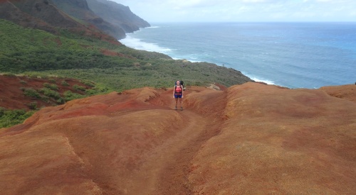
The red clay towards Kalalau
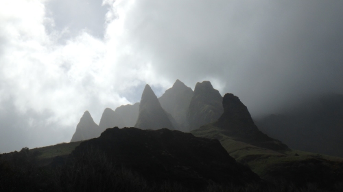
‘The cathedral’
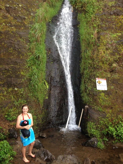
Our shower (an actual waterfall, the tubes are used to direct water flow to make it feel more shower-like)
Day 3: We woke up feeling refreshed, having slept for 11(!) hours and having not been bothered by the rain overnight. As we had been sleeping in wet gear and were borderline fed-up of the rain at this stage (and being Irish/almost-Irish we have a high tolerance for it!) we decided to bite the bullet and hike the full 11 miles back to the start of the trailhead that day- we knew that the rain was only going to continue and we didn’t want to be stuck across any rivers if their levels rose. This way we could get back to our car, our dry clothes, and maybe even a hostel/hotel. We were only 30 seconds after packing the tent when the rain began… 15 minutes in we hit our first river, and we realised that we would have a problem. All of the lovely stepping stones of the day before had disappeared, covered by an extra 20cm of river. We very carefully plotted a route, involving large sticks and some acrobatics. We made it across eventually and had even managed to keep our feet dry. Looking back now I don’t know why we bothered… As we climbed the red clay out of the valley it really started lashing. We took 2 steps forward for every 1 slide backwards and eventually got on to a proper path. We knew we would have to make up time now, so we tried to accelerate on the ‘easier’ parts, but that was tricky as almost every path had become a mini-river. At 11am we passed through our campsite of the first night- it looked like a graveyard. Everything was absolutely drenched, each flat piece of land had turned into a pool. It was only then that we realised that not a single person had passed us travelling the opposite direction all morning…
Anyway, the river crossing here was also a lot trickier than it had been the day before, but luckily somebody had already strung a line across it. We cautiously stepped across, and luckily both made it in one piece. We were now really starting to worry- we knew that the river at mile 2 would be the worst. It was the widest and was well-known for being dangerous. We walked as fast as we could from the campsite at mile 6 to mile 2, as it continued to pour down, and became more concerned as we met 3 groups of people hiking the opposite direction to us- all of them said that the river had been dangerous already when they had crossed, and all said that they were worried it would be impassable for us. They also mentioned that the forecast had changed since we had started the trail, and that the rain was now expected to last at least a couple more days. One of the groups, a couple, asked how the conditions of the rest of the trail were, and when we explained what we had seen we actually managed to convince them to turn around and leave with us. There was an extra dodgy river to be crossed, which wasn’t even marked on the map as it had been an insignificant stream before the rains began. We waded through, and the deepest part was just above our knees- but it was extremely fast flowing and really quite frightening. We were 100% soaked at this stage, and had given up on trying to find shelter during the worst of the rain. We pushed on and finally reached the river. In fact, we heard it before we saw it- a massive thundering came from the valley as soon as we came around the headland. We weren’t sure whether it was the sound of the waves or the river, but as we approached we saw little groups of people sitting by the river, waiting. Luckily the rain had just decided to stop at this stage, so we walked down to talk with them. Clouds still loomed overhead but the rain held off for a little while. The river was completely brown, and about 20m across. There were only a handful of rocks visible throughout the whole thing, and none on the way to the trail on the other bank. We spoke to a couple of Germans who had been waiting there for a while and had last seen someone cross an hour previously. Apparently it had been an experienced looking hiker who struggled to cross, and had to carry his backpack on his head as the water had been to his waist. The river had also risen by about a foot since then. Nobody had any phone signal, and there were no emergency phones anywhere. As we sat and waited, in our damp clothes, time ticked on and sunset became more of a threat. After a while a group of young boys came to the other bank of the river, and had one adult with them. We shouted across the river, asking them to try to get help. It took a few goes to make them understand, as nobody could hear anything over the sound of the river. A few other people came and went at the opposite bank and we shouted the same thing to them. A couple stopped to take photos of us, and even selfies with us stranded in the background (eh, thanks?). In the meantime, some of the braver group members (there were about 20-30 of us at this stage!) on our side of the river tried to figure out ways to get across, some trying to check river depth with sticks, others trying to tie together bits of rope to make a line that would reach the other side. After a few hours, a group of 5 people arrived to the other side, and for the first time seemed to really realise that we were stranded. They did their best to help us- catching the ropes that we threw and trying to find big logs that we could use. Unfortunately it didn’t work and they had to give up. Not until they had thrown us all the food and water in their bag though!
After this group left, a couple of people on our side became really desperate to get across and decided to chance it. One man, walking very slowly made it across while holding onto a rope. It was obvious that he was struggling against the current – he was up to his chest in rapidly-moving water, and he wasn’t able to do it with a backpack on. The rope was really thin (just a few guy lines from tents knotted together) and in fact, as they tried to pass a backpack over on it, it snapped. Luckily there was nobody attached to the line at the time, but the backpack was lost for good.
We gave up on that option for a while, and I left to set up our tent for the night as we had decided that it wasn’t worth the risk of trying to cross- even if that meant spending the night in our cold, damp tent. After a few minutes I heard shouting coming from the river, so I ran back down. It turned out that some of the group had decided to chance the usual crossing route (the river had come down about 5cm at this stage). They held on to each other and had strung a rope across this part also. But the river was still extremely strong and multiple people only made it a few metres across before having to turn back. The river was at chest height on everybody, and wearing backpacks meant that there was extra surface area for the river to push against. One couple decided to try their luck, and crossed together (it was the same girl who’s backpack had already been lost) but at one point she lost her grip on the rope. We all inhaled in unison- it seemed as though she would certainly be washed away. She was pushed about a metre downstream before her partner managed to grab her. All of this happened in the blink of an eye. They decided to keep going (they were about halfway across at this stage) and struggled across- slowly. Approx 5m from the opposite bank they both lost hold of the rope at the same time- it was horrendous to watch. Luckily some of their friends managed to throw in a huge tree branch for them to grab on to, and the partner had to pull the girl up on to it. Milliseconds later and they almost certainly would be dead.
By the time they had landed on the other side and had caught their breath they were already shouting across to us not to try to cross. But we had already decided- we were staying put for the night. They promised to call for help and wished us luck, and set off back to the trailhead.
We retired to our tents, about 15 of us left behind, feeling a little despondent. Just after sunset we heard shouting coming from across the river again- 2 lifeguards from the nearest beach had hiked up to us and were radioing info to the emergency services. They asked questions of us- were there any babies or older people with us etc. They said that if the rivers didn’t drop by the next day they would arrange for a helicopter to lift us out. Finally, they mentioned a locker at the nearest helipad which was stocked for emergencies such as this, and gave us the code.
As I cooked dinner and we tried to share out our emergency food among those who didn’t have any left (I felt a little bit guilty giving hungry people cheese strings but I’m sure they didn’t mind) Luca and some others hiked to the helipad. They came back with torches, emergency blankets, huge boxes of granola bars, glucose tablets, and bottles of water (the one thing we definitely weren’t running out of!). We all felt a little better about the night ahead, and finally got to sleep to the sound of only light rain.
The next morning we all woke up before sunrise and waited for the moment of truth… And there it was- the river had dropped! We packed up quickly and ran to the river- it was blue and clear, and there was a ranger on the opposite bank with a megaphone directing us. The first people crossed and the river was at their hips- a massive improvement on the day before. We eventually struggled across and it only hit us as we hiked back to the trailhead – we made it!
As we walked back, we met some people travelling the opposite direction who had already made the crossing the day before- they were coming back to check that we were all ok- so nice! They even gave us a lift to our car at the end. (We later bumped into them in a coffee shop, and then in the airport too…)
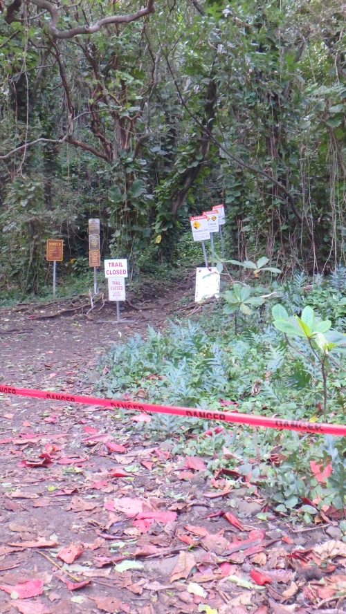
Just as we came back to civilisation we noticed some red tape strung across the trail with ‘DANGER’ written across it. When we emerged from the trees we saw police, reporters, and a crowd of disappointed hikers. It turned out the trail had been officially closed and the news of stranded hikers was drawing in some onlookers. You can see the news features here and here. (Just to be clear- we were not airlifted out, in fact the reports say that helicopters couldn’t access the area due to weather but tourist helicopters seemed to have no such issue. Also, Luca and I are not the couple mentioned in the news. Finally some comments on the above news websites have suggested making tourists pay for rescues- considering every tourist pays 60$ if camping 3 nights, and there are no other services provided or staff present, the least they could afford is a bridge over the river or at the very least an emergency phone. Anyway…)
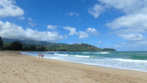
When we got back to our car we decided to dry out in the sunshine before going for fresh espresso + fresh bread- perfect! We also visited Hanalei beach, which features in the movie ‘The Descendants’ (that one with George Clooney). We ate more poke and visited more beaches and slowly made our way to the Waimea Canyon.
Hanalei beach
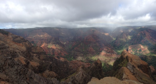
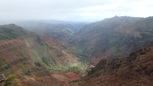
This is a huge canyon with a beautiful drive along the length of it – we spent our time driving slowly up the winding roads, stopping along the way to look out over waterfalls and rivers. When we reached the top of the road (it stops just after an air force base) there is a huge lookout station that actually looks back over the isolated Kalalau trail. We camped that night at Koke’e state park (can book here) which was lovely and soft compared to our previous few nights!
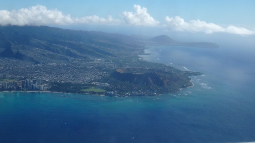
The next morning we drove back to Lihue airport via the Salt Pond beach in Hanapepe- a beautiful secluded beach that has a natural rock wave-breaker. We dried out all our equipment there while looking for honu (sea turtles)- unfortunately we didn’t spot any this time. A quick pit-stop at the supermarket to buy macadamia nuts, postcards and Hawaiian coffee and we were off back to the UK via Honolulu.
Hawaii- we will be back again soon! Mahalo!